
Kalakriti Archives
Hyderabad · Est. 2002 · Google Arts & Culture Partner
Kalakriti
Archives
Seven centuries of South Asian cartographic and visual heritage, preserved in one of India’s largest private archives.
Preserving what might
otherwise be forgotten
“Some collections are built. This one was rescued.”
Kalakriti Archives was founded in 2015 by Hyderabad-based collector Prshant Lahoti to institutionalise and preserve one of the most significant private collections of historic maps and vintage photographs in India — the Prshant Lahoti Personal Collection (PLPC).
Built over more than a decade, the archive holds over ten thousand historic maps and plans spanning seven centuries, and approximately nine thousand vintage photographs from the nineteenth and twentieth centuries, alongside etchings, prints, Cherial scrolls, Bollywood posters, rare books, Bidri ware, signed cricket memorabilia, and historical objects.
Its collections form a comprehensive pictorial and cartographic record of major Indian cities — Hyderabad, Bombay, Calcutta, Madras and Delhi — as well as princely states, Himalayan regions, sacred pilgrimage geographies, and cosmological traditions of the Indian subcontinent.
Born and raised in Hyderabad, Prshant Lahoti began collecting antique maps and vintage photographs in 2002. Over the following decade he assembled one of the most extensive private collections of Indian cartographic and photographic heritage. In 2015 he founded Kalakriti Archives to make the collection accessible to scholars, researchers, and the public.
Seven centuries.
One archive.
Over ten thousand maps spanning colonial city surveys, princely state territories, Himalayan frontiers, pilgrimage routes, cosmological traditions, indigenous cartography, and early European representations of the Indian subcontinent.
Approximately nine thousand photographs from the nineteenth and twentieth centuries — spanning cityscapes and panoramas, architectural records, ethnographic portraits, archaeological documentation, and Himalayan landscape studies.
Etchings, aquatints, lithographs, decorative prints, and vintage Bollywood posters — hand-painted and lithograph-printed — documenting Indian cities, landscapes, ceremonial life, and the golden age of Indian cinema.
Cherial scroll paintings — a living folk art tradition native to Telangana, where the Nakashi community narrate mythological epics through vivid, hand-painted narrative scrolls. Rare examples of an endangered tradition.
A library of rare and antiquarian printed volumes — illustrated natural history books, early travel accounts, colonial gazetteers, explorers’ journals, atlases, and geographical compendia of the Indian subcontinent.
Fine examples of Bidri ware — the inlaid metalwork tradition of the Deccan — alongside an exceptional collection of cricket memorabilia featuring signed bats by legendary Indian and international players.
Eight traditions
of spatial knowledge
Colonial urban surveys of Hyderabad, Madras, Bombay, Calcutta, Delhi and Lahore — mapping India’s great cities street by street.
Territorial maps of the Nizam’s Hyderabad, Mysore, Baroda, Travancore and other princely states — the political geography of pre-Independence India.
Jain Jambudvipa maps, Hindu Mount Meru diagrams, Buddhist cosmological charts, and Indian astronomical star maps — sacred geography of the universe.
Illustrated routes to Char Dham, sacred Kashi ghats, Vrindavan parikrama paths and temple town plans — devotional cartography of India.
Survey maps of Kashmir, Ladakh, Darjeeling and the Northwest Frontier — the Great Game in cartographic form and the mapping of India’s mountain borders.
Pre-colonial Mughal-era cartography, folk maps in Warli, Gond and Pattachitra traditions, and village settlement plans — indigenous spatial knowledge systems.
Coastal trade maps, river systems, railway network surveys and Deccan plateau cartography — the infrastructural and commercial geography of India.
Early European maps of India from the 16th–18th centuries, Indian Ocean trade charts, and Survey of India national maps.
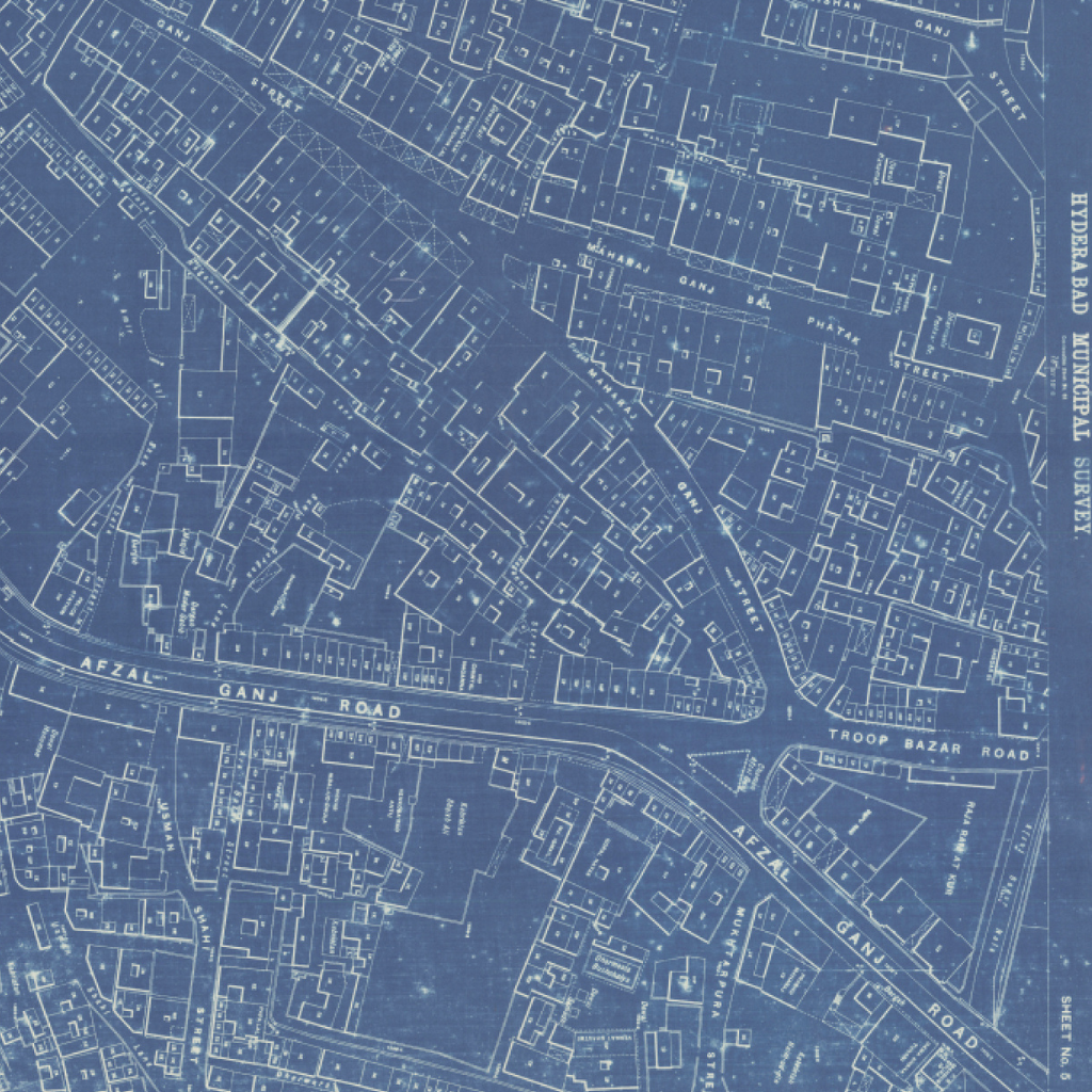
The Munn Survey
of Hyderabad
In 1908, the Nizam of Hyderabad commissioned one of the most remarkable urban surveys in Indian history. Following devastating floods, engineer Leonard Munn — Chief Inspector of Mines under the Nizam regime — led a comprehensive mapping of the entire city.
The resulting 550 maps document Hyderabad with extraordinary precision: every street named, every landmark recorded, every resident’s name inscribed. It is not merely a map of the city — it is a portrait of its people.
Kalakriti Archives holds the most significant private collection of Munn Survey maps in existence. Approximately 650 maps have been digitised in partnership with Google Arts & Culture and made freely available to researchers worldwide.
The collection,
on the world stage
Exhibition of regional and religious maps from the Indian subcontinent at one of Asia’s foremost contemporary art festivals.
First private archive in India selected as a Google Arts & Culture partner. Over 650 Munn Survey maps digitised and made freely available to researchers worldwide.
Cosmology to Cartography: A Cultural Journey of Indian Maps — curated by Vivek Nanda and Alexander Johnson. 72 vintage maps exhibited, 70 from the Prshant Lahoti Personal Collection.
curated by Ranjit Hoskote at Adil Shah Palace in Panaji, Goa — 20 from the Prshant Lahoti Personal Collection.
Kal Aaj Aur Kal — 50 photographs and maps presenting a tri-perspective of Hyderabad across past, present, and future.
Exhibition at the Indian Institute of Management Bangalore and the annual Krishnakriti Festival, Hyderabad — attended by over 5,000 visitors each year.
The World from Asia: A Cartographic Story — Maps from the collection at France’s foremost institution for Asian art and culture.
Mapping the World: Perspectives from Asian Cartography — The exhibition, held in partnership with the Embassy of France in Singapore, features over 60 treasures from overseas institutions and private collections such as the Bibliothèque nationale de France, Musée Guimet and École Française D’Extreme-Orient in France, as well as Kalakriti archives.
Regular participation as exhibitor at the India Art Fair — India’s most significant annual platform for modern and contemporary art.
Knowledge preserved
in print
A history of Secunderabad’s growth from cantonment to English town, illustrated with vintage photographs from the Kalakriti Archives. An essential resource for the history of the Deccan.
Written by Vivek Nanda and Alexander Johnson. Traces India’s cartographic heritage from medieval cosmological manuscripts to colonial-era scientific maps. Published by Kalakriti Archives and the National Museum in collaboration with the Ministry of Culture, Government of India.
50 photographs and maps from the Kalakriti Archives alongside contemporary images of Hyderabad — a seamless visual history from the late nineteenth century to the present day.
Catalogue for the 16th Krishnakriti Festival, themed around the concept of the city as archive. Documents exhibitions, seminars, and archival materials from the Kalakriti Archives collection.
“The first private archive in India to partner with Google Arts & Culture — making seven centuries of South Asian cartographic heritage accessible to the world.”
View on Google Arts & CultureOpen to scholars,
researchers & visitors
The archive welcomes scholars, historians, researchers, photographers, artists, and institutions working in the fields of South Asian history, cartography, photography, ethnography, architecture, and cultural heritage.
Kalakriti Archives offers internships for young scholars and fellowships to work on specific areas of the collection. Archival resources may be used for exhibitions, publications, and artistic interventions under appropriate copyright and licensing arrangements.
To make an appointment, enquire about research access, or discuss collaboration, write to us at ea@kalakriti.in
Road No. 4
Banjara Hills, Hyderabad — 500 034
Telangana, India
Krishnakriti Foundation · Artcafe.in